Not enough is said about real lives in prehistory, in my view. However, the stone structures of thousands of years ago survive and settlements such as the one surrounding the Talayot at Santa Monica, tell a tale of toil, with discarded snail shells and the remains of wheat and fennel in land cleared of rocks nearby.
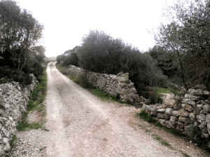
Santa Clara has another such settlement a mile away, just beyond the next farmhouse down towards Santo Tomas. There is an old stone track heading down to the beach.
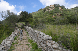
Whether small settlements, factories or villages, they share some features and have their own unique aspects too. There are numerous pieces of pottery and even a carbonised rock next to a burnt out tree stump. A sophisticated rock-surfaced path leads from the talayot to the road.
Ancient villages in Menorca have more stories to tell and are well worth exploring them.
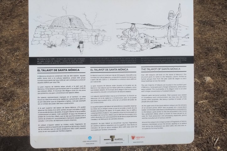
Santa Monica – Talayot
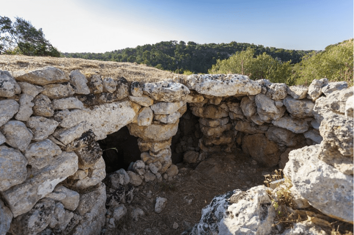
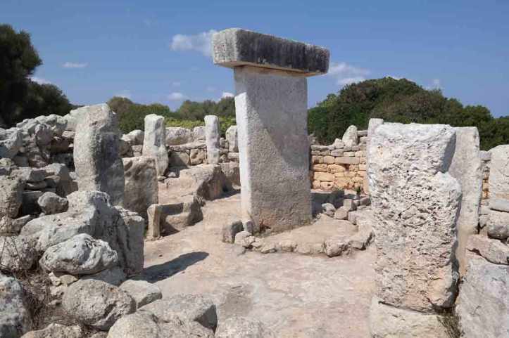
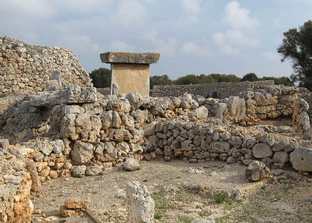
Santa Monica has its own Talayot and the archeology people have now erected a second new sign about it with more information. There is a small tunnel on the side of the talayot that can be crawled through by a small person to reach the top.
Talayots are said to have been built between 850 and 350BC, but that may be due to carbon dated materials from much later. Discarded snail shells in pockets in the main structure wall and broken pieces of pottery suggest eating and storage. An area cleared of stones has remnants of various plants including wheat and fennel. Official reports say the Talayotic culture disappeared from Menorca and Mallorca at the beginning of Roman occupation. I found a stone with a fossil of tiny seashell amongst the broken pottery.
When the Romans took Menorca, natives were employed as slingers having built up excellent skills using this weapon to hunt and other uses although they had always been a peaceful people. Like a similar site situated in Mahon, the talayot at Santa Monica shows plenty of evidence of food production, with various plants including, fennel, wheat and grain gowing nearby. There is plenty of evidence of activity, with markings on the edges of pottery suggesting manufacture, piles of empty snail shells, made fragile with age, carbonised wood and small enclosed areas, which may have been used for production.
Galliner de Modana – Es Migjorn Gran
This structure has been recently discovered and excavated and more info is on this website, which can be emailed here to arrange a visit. It sits at the top of a baranc, a valley, which runs from Es Migjorn Gran to Bini Gaus, where there are two caves and the Sant Augusti Talayot, which has also received recent attention and excavation. The structure called Galliner de Modana suggests it may have had an upper level and would make a worthwhile stop on a walk around the many prehistoric sites south of Es Migjorn Gran.
Sant Augusti – Es Migjorn Gran
Excavations of this talayot and remains hidden beneath trees beside it suggest a settlement as well as a communication beacon and look out tower. Uniquely, Sant Augusti Talayot has an open interior with a strong central pillar and a wooden beam, entered from ground level. Overlooking the baranc or valley right beside it, the latest and deepest sunsets can be viewed from the top of this talayot. It is of course a good idea to take a torch light for the walk back. It is also possible to reach the Cave de Coloms (see below), which is quite near Santa Augusti and can be accessed by climbing over a low wall and following a zig zag stone path down.
Monte Toro – Es Mercadal
In the middle of the island sits one mountain of 342 m (1,122 ft): Monte Toro. Starting as a place of pilgrimage in the 13th century with a shrine, in the 15th century a watchtower was built for lookout and defense. Augustinian monks built the current sanctuary in around 1670 and called it Sanctuary of the Virgin of El Toro. It remained a monastry until church property was confiscated in 1835 and then the site was destroyed and looted at the start of the Spanish Civil War in 1936.
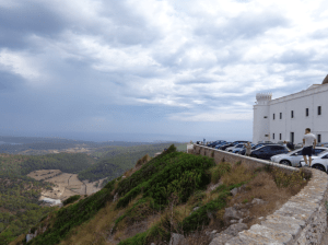
Part of the original defense tower still stands and has been renovated, providing the older brick wall of the courtyard beside the church near an ancient well. Monte Toro can be seen from all over the island and affords great views of the coastline all around. Menorca also has a good mobile signal, since the transmitters are up there and can be seen from the restaurant’s outside terrace. There is a gift shop too and a favourite snack in the cafe, originally made by nuns or church wardens living there, are the macaroons that melt in the middle when freshly baked.
Kane’s Road
In 1712, Queen Anne appointed Richard Kane as the first governor of Menorca. The island was very poor at the time and Kane petitioned the English government for funding to help make the island more self sufficient as Kane said “it is our resolution to make you a rich and flourishing people.”
Santa Agueda – Roman Road
Another walk takes you along an old Roman road and past a hill fort built by the Arabs from the Caliph of Cordoba. Read more by following this link about Santa Aqueda and walks along Menorca’s Roman Road
They (the Arabs) built an amazing palace to defend themselves from the invaders and for Arabian chief to holiday with musicians, thinkers, poets and artists from the Arabian world in there newly acquired Island they called Manûrqa
Sanitja – Roman Port
To the west of Fornells in an inlet, Sanitja, originally called Saniserra, is the first population centre occupied by the Romans when invading the island during the Punic Wars. The inlet is a natural harbour and is said to be the best place on the island to view the setting sun.
This guide tells you more, including:
When visiting Sanitja, you may also visit the lighthouse of Cavalleria and the magnificent coves of Cala Viola, one of the calmest and quietest of the island, and Sanitja Tower, built during the British rule of the island.
Much further back in time…..
Menorca is steeped in history and over the last three decades, excavators have put an ever increasing amount of ancient sites on the map.
Taula den Torralba den Salord – Alaior.
On the old road to Cala’n Porter is a standing stone, which once stood beside the road. Now the whole pre-historic dwelling has been excavated and a walkway round created for visitors. Entry is €4 (concessions are cheaper) and the road takes you past a large talaiot, across the old road, since diverted around the site, past the standing stones, through caves, past a crumbling temple, through a farm and around past an ancient wall, more caves and back to the visitor booth, where chilled drinks and ice creams are served.
Son Catlar – 7.5 km south of Ciutadella. Take the road Cami De Sant Joan de Missa to Son Saura (beach) then 3km further along.

Another ancient settlement, which was occupied up until the Roma era in Menorca. A Talaiotic settlement, Son Catlar has an intact surrounding wall of 1 km in length and 2cm thick, with large stone blocks placed together to not require mortar to hold them in place. The entrance way is preserved, with four Talaiots inside and the remains of rooms.
Cala Morell – Carrer Lira, 7, 07769 Ciutadella
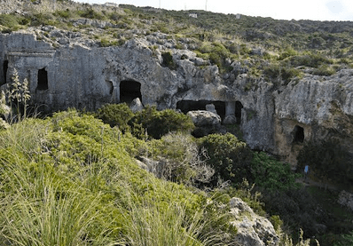
Near a quiet fishing village in the north west of the island is a series of man made caves dating back to the Bronze and Iron ages, lived in as well as used for burials. This is worth a visit on the way to the village and beach of Algaiarens and the Necropolis provides a 2-3 hour excursion.
Torren den Gaumes – Alaior, 07730, Menorca.
Considered the largest ancient settlement in the Balearic islands, this also dates from the pre-talaiotic period up to when Roman times. This is near Son Bou and has a defensive wall, three look out talaiots (watch towers) and a temple. Access is restricted for conservation.
Here is a Google map of the talaiotic culture of Menorca.
Naveta des Tudons
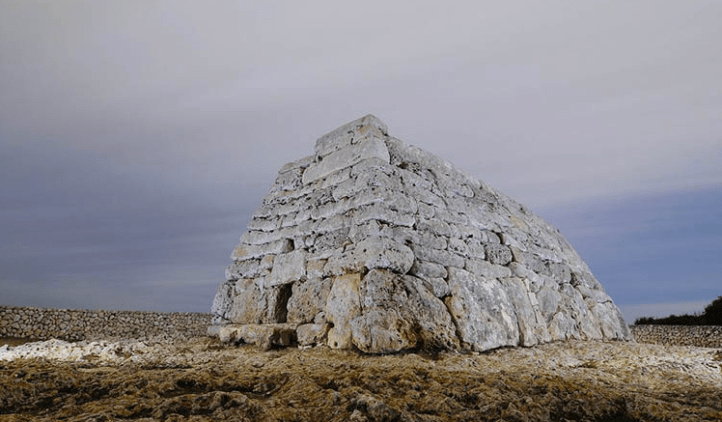
Naveta means ‘little boat’ and this pre-talaiotic building was used for burials. Reminiscent of a similar shaped construction existing in County Kerry, Ireland, this was in use around 2000 years ago. Visitors are not allowed inside, so here is a Vimeo video to experience it.
La Naveta des Tudons is one of Menorca’s most famous monuments and is 5km before reaching Ciutadella, visible behind the carpark right beside the Mahon-Ciutadella road.
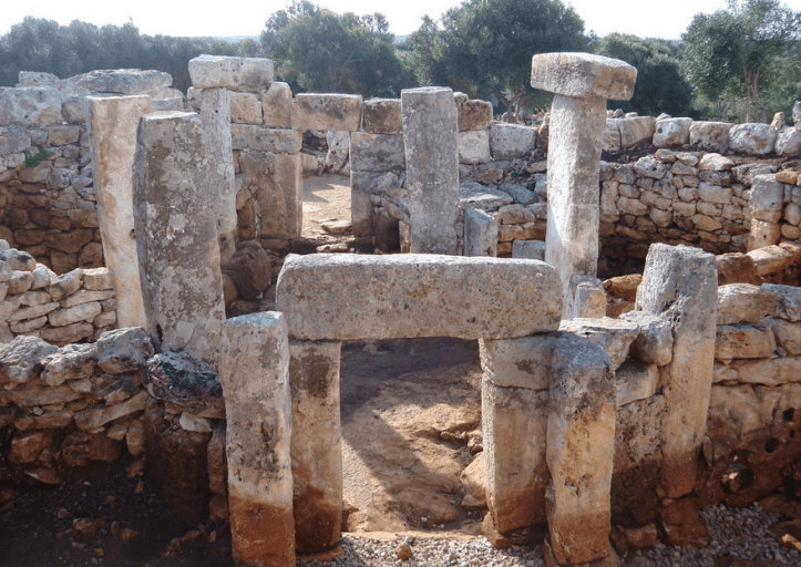
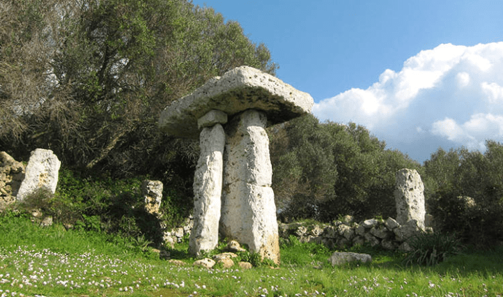
Talati de Dalt
Another megalithic village stands at Talati de Dalt. Again, this dates from 1,000 BC up to when the Romans reached Menorca in 123BC. This settlement has visible foundations of private talaiotic circular houses plus a room covered by stone slabs held up by a central column. There are two natural caves near the site, for which a use has not been confirmed.
To reach Talati de Dalt from Santa Monica, pass Alaior by 8km and turn onto Cami de Talati on your right. The site’s car park is 4km from Mahonjust 400m on your left after leaving the main road.
Torrellafuda
This is a small settlement with an enclosure covered by a wild olive grove, occupied until the end of the Roman period. There is a Talaiot, rubble filled well, two entrances more recently enhanced by dry stone walls and the Taula enclosure with stone dwelling remains.
Heading from Sta Monica on the main Mahon-Ciutadella road you pass Castillo restaurant on your left, about 9km before Ciutadella, the farm track is the next left turn. With unlimited free access, this is approached along a track which leads up to then 1km to your right around Son Sintes farm to parking. A footpath runs through a field and the talaiot is clearly visible up ahead.
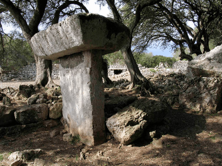
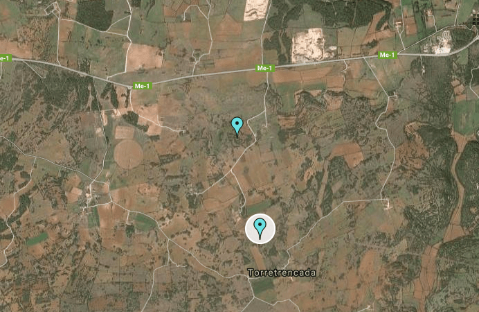
Torretrencada
This is one of the smallest settlements but still worth a visit. The rock has had anthropomorphic carvings for tombs, a man made cave burial chamber, a crumbling Talaiot and the Taula without an enclosure wall still standing. There is another example of a Hypostyle room covered by stone slabs over a main central stone column.
To reach Torretrencada, a little off-the-beaten track excursion is required. On your way towards Ciutadella, before the Torrellafuda turning, take a left off the main Me-1 road onto a track called Toni Marti. This passes a farm (to your left) on route then turns right at another farm onto Cami Torre Trancadeta, which winds its way around a third farm, to its right, then further on is a 3 road junction with a little parking space. Torretrencada can be approached via a walk through farmland. See this map:
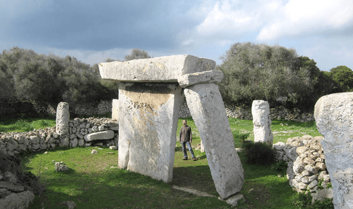
Trepuco
Just 1km from central Mahon stands a 500 square meter settlement from the Talaiotic period, which took a big hit during the Second Punic War of 218 BC, and was finally abandoned after 123 BC. Today, two Talaiots, the Taula enclosure, parts of the surrounding wall and some remains of dwellings can still be seen.
Here is a video of the site:
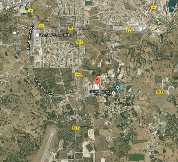
The closest way to approach Trepuco is enter Mahon on the main Me-1 road, turn right onto the ring road (directly opposite the road on your left down to the port). This road is called RM and takes you to Hospital Mateu Orfila. Trepuco is directly the other side, so take the first exist on the large roundabout (hospital in full vision) and at the next roundabout go straight over, crossing the Me-8 road to San Luis. Seeing this map (Trepuco marked with a blue pin) will put this into perspective. Very close by is another ancient settlement (you will pass on your left) called Pabellon Menorca (18, Calle Bintaufa, cr, 18, 07702 Mahon).
These sights would keep the most enthusiastic archeology and history sightseer happy for a few holidays, so here are some restaurants to keep you well fueled on your travels.
